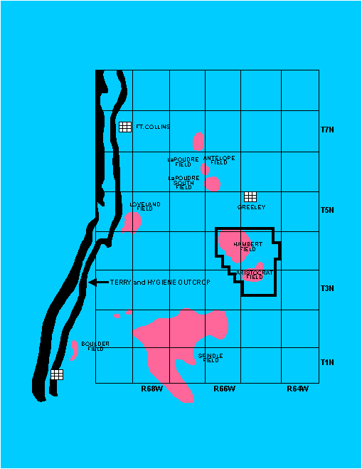
Previous studies of the Terry Sandstone in the Hambert-Aristocrat Field area
In the 1970's-1980's, most linear sandstones deposited within the Cretaceous Western Interior Seaway were interpreted as offshore shelf ridges or bars (Berg, 1975; Hobson et. al. 1982; Tillman and Siemers, 1984; Turner and Conger, 1984, Beaumont, 1984; Slatt, 1984; Tillman and Martinsen,1985; Gaynor and Scheihing, 1988, Gaynor and Swift, 1988). The Terry Sandstone in the Hambert-Aristocrat area is no exception. Porter and Weimer (1982) interpreted the Terry Sandstone in the Spindle Field area as offshore shelf bars and Siemers and Ristow (1986) invoked offshore processes for the Terry Sandstone in the Antelope-LaPoudre Field area, north of the Hambert area (Fig. 1).
However, considerable research in the late-1980's and 1990's (for example, Leggitt, et. al., 1990; VanWagoner, et. al., 1990; Walker and Eyles, 1991; Pattison and Walker, 1992; Bergman, 1994; Hart and Plint, 1994; and many papers in VanWagoner and Bertram, 1995), coupled with the acceptance of sequence stratigraphy concepts, have resulted in general agreement that most of the linear sandstones deposited within the Cretaceous Western Interior Seaway are shoreface deposits. Standard arguments against a 'shelf' sandstone model, which can be explained by a shoreface model, include: (1) depositional discontinuities that are sometimes overlooked in shelf sandstone interpretations, (2) the lack of a satisfactory explanation for transporting large quantities of sand across muddy paleoshelves and reworking them into ridges during static sea level, and (3) the presence of shoreface trace-fossil assemblages (Bergman, 1994). Our interpretation of the Terry Sandstone as a shoreface deposit is discussed in more detail below.
Also in the 1970's and 1980's, the Denver Basin, as well as other Rocky Mountain basins, were considered to be structurally simple, so that many oil and gas fields were thought to produce from stratigraphic traps. Again, Hambert-Aristocrat Field is no exception. Based upon well control, Sonnenberg (1982) mapped a relatively simple structure over Hambert Field. A later structural interpretation of conventional 2D seismic data (Davis,1985) indicated a northeast-trending set of listric normal faults across Hambert Field. More recently, Weimer (1996) has re-interpreted structure in the Denver Basin to be dominated by basement-controlled wrench faulting, which has resulted in a complex pattern of northeast-trending faults with a secondary northwest trend, and associated folds. A similar complex pattern is emerging from detailed work in other Rocky Mountain basins (Martinsen and Olson,1996).